Walking the Causeway Coast Way
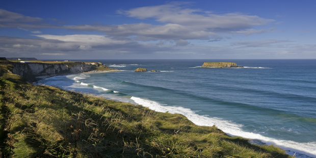
Walking the Causeway Coast Way will be an experience that will stay with you forever. This two day walking route, which is 51 km in length, takes you along Northern Ireland’s north coast, where you will encounter the most amazing scenery and landscapes in the whole of Europe!
Famous Landmarks
The walking trail links two popular tourist towns of Ballycastle and Portstewart in Antrim and takes you along the rugged coastlines that include two of the most famous landmarks in Northern Ireland: the Giant Causeway, which is a World Heritage Site and Carrick-a-Rede Rope Bridge. The Coast Way is an area of outstanding natural beauty that includes the most dramatic cliff and rock views, sandy beaches, numerous historic and natural landmarks and scenery that will take your breathaway.
The navigation of the Causeway Coast Way is quite straightforward and is well signposted. You will encounter different terrains along your trek, which will include cliff walks, beach walks, promenade walks and occasional road links. The hike is a linear walk and is suitable for novice walkers, who have a reasonable level of fitness. Accomplished walkers will also find the route rewarding.
The walk can be completed in sections. There is a good public transport infrastructure in the region, so you can join the walking route at any point. There is also a good selection of B&B accommodation available in the towns and villages along the Causeway Coast Way.
Section 1
Portstewart to Portrush is 16km in length. Expect spectacular views and a terrain consisting of beach, promenade and cliff walks. Along the route you will encounter O’Hara’s Castle (now a school) and Portrush Harbour. If you take a slight 20m detour at the start of your walk you will be able to visit St Patrick’s Well.
Section 2
Portrush to Porballintrae is 9.3km in length. Expect spectacular coastal views with a terrain consisting of beach, cliff and road walks. Highlights of this stretch of the walk include a long sweeping beach and a medieval castle. Dunluce Castle is perched magnificently on a rocky outcrop above the sea. You will definitely want to take a pause in your journey to explore this amazing castle.
Section 3
Portballintrae to The Giant's Causeway is 4.3km in length. Expect spectacular views and a terrain that is completely off road with beach and cliff top walks. For some of the route you will be walking beside the track of the Giant’s Causeway and Bushmills Railway track. Although you probably won’t be aware of this, at one stage of the route you will be actually be standing on the grass covered roof of the Giant’s Causeway visitors centre!
Section 4
Giant’s Causeway to Dunseverick Castle is 7.3km in length. Expect dramatic scenery with a terrain of cliff top walks. The point of Hamilton’s Seat, at the tip of the headland, marks the highest point of the entire Causeway Coast Way walk. A highlight of this stretch is the Giant’s Causeway shoreline rock formations. Along the trek is a cove known as Port na Spaniagh which contains the wreck of the Girona, one of the ships from the ill-fated Spanish Armada. In the 1060’s, a team of divers salvaged the greatest haul of Armada treasure ever recovered and it is now on display in Belfast’s Ulster Museum. Nearing the end of the walk you will encounter the ruins of Dunseverick Castle.
Section 5
Dunseverick Castle to Ballintoy Harbour is 7.8km in length. Expect spectacular scenery and a walking terrain of beach, road and cliff walks. This walk is dependent on tide times and will be impassable at high tide. A highlight of the walk is Porbradden village which is home to St Gobban’s Church, which happens to be the smallest church in Ireland! White Park Bay contains numerous sand dunes that provide protected habitat for many types of fauna and flora. The area is also one of the first places in Ireland to have Neolithic settlers and many tools and tombs have been unearthed around the cove.
Section 6
Ballintoy Harbour to Ballycastle is 12.6km in length. The terrain consists of cliff, road and open farmland. Highlights of the walk include the chance to walk across the famous Carrick-a-Rede Rope Bridge, which provides spectacular views over Tathlin Island and Scotland’s Mull of Kintyre. The walk commences in Ballintroy Harbour which is a lovely, picturesque and tranquil location and the Diamond in Ballycastle is the official end of the Causeway Coast Way walking route.
Book an Antrim B&B 
Posted: 02 Oct 2013 by
Claire Regan |
with 0 comments
Tags: Northern Ireland, Walking, Walking Trails
The Great Western Greenway is a popular walking and cycling trail located in County Mayo, along Ireland’s Wild Atlantic Way.
Posted: 17 Aug 2021 by
Claire Regan |
with 0 comments
The greenway is 130km of level towpath that is suitable for walkers, runners and cyclists of any age. The trail will take you across four counties of Kildare, Meath, Westmeath and Longford.
Posted: 29 Mar 2021 by
Claire Regan |
with 0 comments
The National Famine Way is a new 167km walking and cycling trail that spans from Strokestown, Co Roscommon to Dublin. This historic trail follows the footsteps of 1,490 emigrants who were forced to walk this route during the 1847 famine.
Posted: 21 Sep 2020 by
Claire Regan |
with 0 comments